All The Ways Up Mission Peak
Anyone who knows me reasonably well knows I have a soft spot for Mission Peak. I grew up in Fremont, and begrudgingly hiked up the Peak with my family every so often, complaining the whole time. It was hot. It was dry. I was thirsy. I was tired. Except for the time was a teenager and took a detour around the Hidden Valley area and headed off-trail, straight up the peak face. That was adventure! (not recommended, of course!)
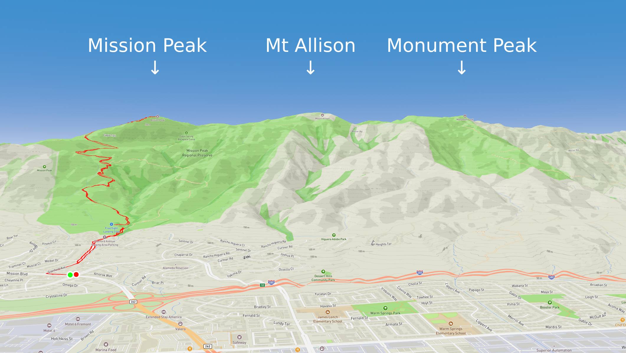
Fast-forward to my late 30s. I was out of shape, overweight, and wanted to do something about it. I found hiking, then running, then the Ohlone 50K race, which goes up and over Mission Peak as its "warm-up hill". In this journey I got to know the area called Mission Ridge, which is a small fold of land next to the Bay that houses Mission Peak, Mount Allison, and Monument Peak. There is a network of trails on this ridge and beyond that can take you dozens and dozens of miles from where you started.
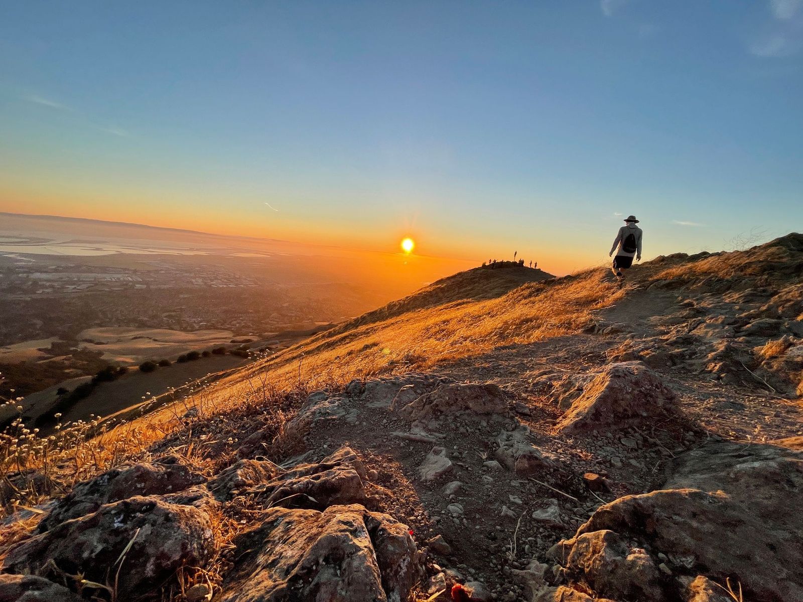
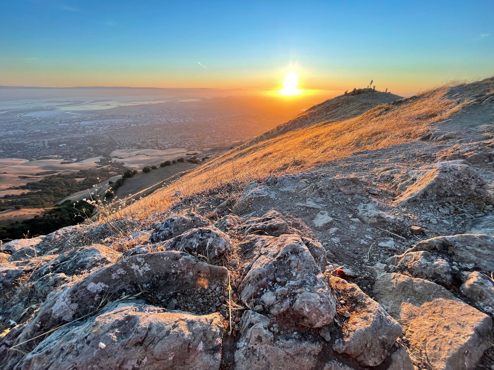
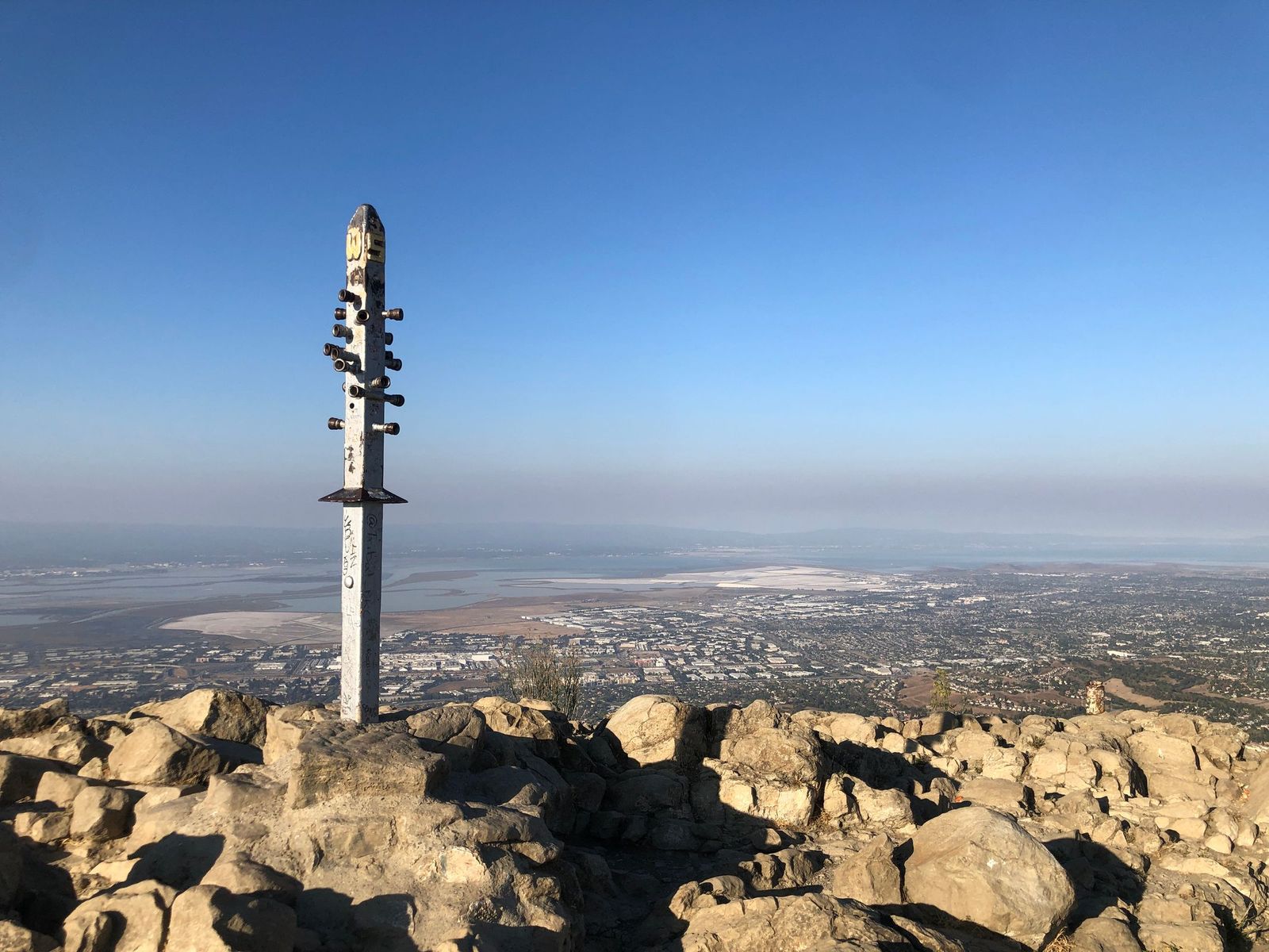
A lot of people know Mission Peak. They know it's a butt-kicker, but they make the slog up from Fremont for fitness as well as the selfie-potential of the pole at the top, to prove to their friends that they too conquered Mission Peak. But I think relatively few people know just how much variety exists in ways of getting to the top. That's what this article is for.
In General
This is a hot, dry place when the weather is warm. Bring at least a liter of water per person/creature. Also when it's warm, you may see a rattlesnake. Don't freak out, just give it plenty of distance and continue on your way. The cows on Mission Peak are the most chill cows ever. Just give them their space (you will be able to see if they are nervous ... just give them more space if that's the case). You may see a coyote. Again, don't freak out. Just clap your hands (or not) and they will run away. You may see turkeys! You may see hawks and eagles! You may see tarantulas! They are harmless. Don't litter!
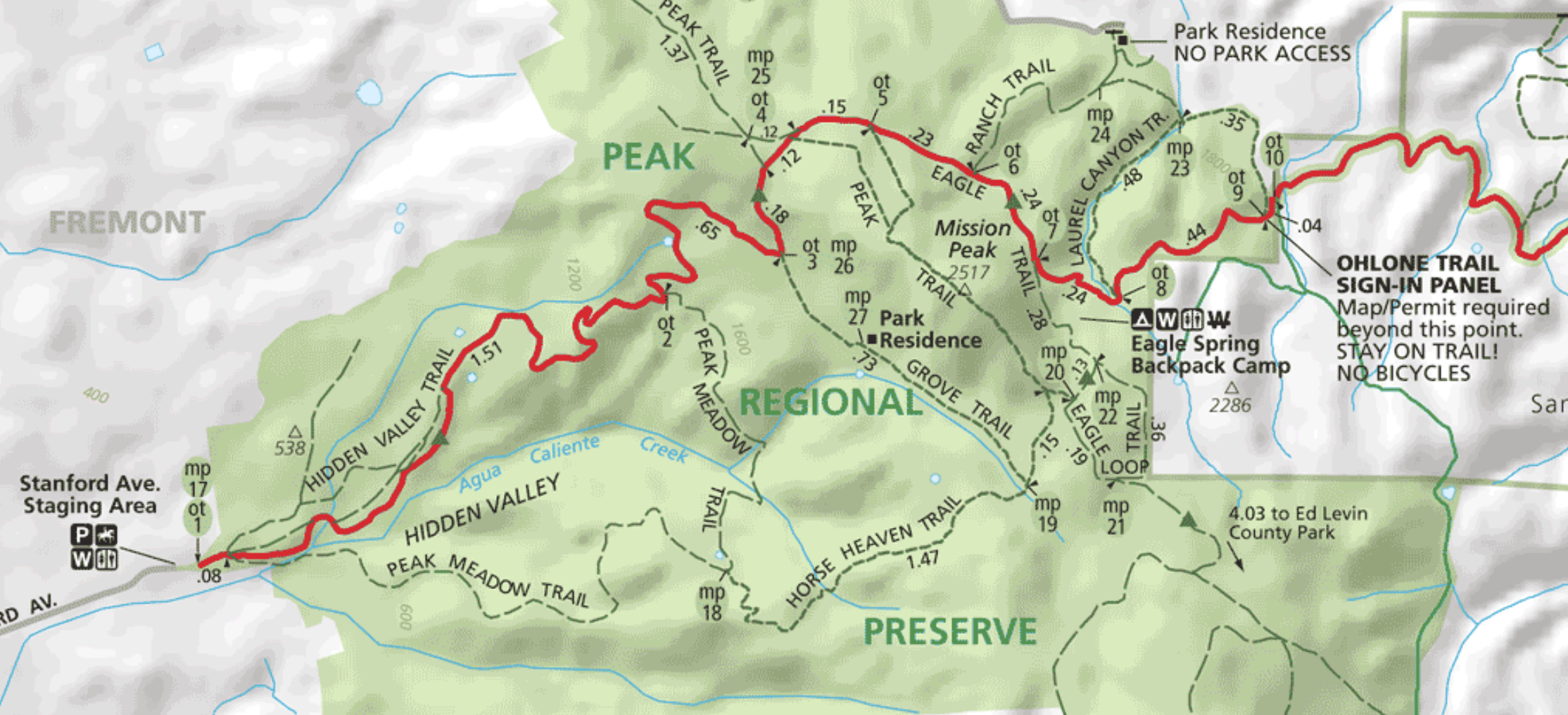
Most Popular: From Stanford Ave Trailhead
Roundtrip Distance: 6 miles / Elevation Gain: 2100 feet / Strava Route / Mission Peak Site
Getting There / Parking
Just off of Mission Boulevard in Fremont is Stanford Avenue. At the top of this street is a small parking lot, a bathroom, and water fountain. If you're lucky, park in the lot. Otherwise you will need to drive back down the street and find street parking. Heed the street parking rules!
The Trail
From the trailhead, push open the gate and begin the hike up. There is a fork in the trail just a few minutes after you start. Stay to the left, unless you want to take the Horse Heaven Trail (detailed in the next section). The trail serpentines up the face of the Peak for 3 pretty consistently steep miles. There are a few places to stop and rest along the way. Just before the last half-mile or so, there is a bathroom, and then the trail wraps around the back of the peak, then makes a right turn (clearly labeled with a "PEAK =>" sign) to make the last steep climb up, finishing with a couple tenths of a mile of rocks.
I've seen a lot of people walking very nervously on the rocky part, but the rocks get so much traffic, they don't move. So pretend you're a mountain goat and just go!
Most Popular in 2020: From Ohlone College
Roundtrip Distance: 6 miles / Elevation Gain: 2100 feet / Strava Route / Ohlone College Site
Getting There / Parking
Ohlone College is an easy destination to put in your GPS. There's a huge parking garage near the trailhead. It is $3 or $4 for parking (not enforced on holidays). After you park, exit the garage where you went in, cross the road, and walk to the trailhead which is just above the tennis courts.
The Trail
While the same distance and elevation gain as its more popular cousin (Stanford Ave trailhead), the Ohlone College route only shares the final half-mile or so, and offers more variety. Head up the hill from the trailhead, go through the gate, then make a hard right turn to begin the first long climb. Pass the large, square house that my family called the "Taj Mahal" when it was built in the 80s, but it's showing its age now. There is some shade at the end of this climb, where the trail turns to the left and goes behind the foothills.
The climb continues and passes a small pond (dry at the end of the summer, sometimes flooding the trail in the winter) before it goes under tree cover for about a half mile. Come out of the trees, and continue up the narrow trail to a gravel road. Make a hard right turn, then ascend the back of the northern "shoulder" of Mission Peak. This is a pretty steep section, which flattens out as you're given a really nice view of the Peak, and a small bathroom ahead. Continue up and to the left after the bathroom, then make the right turn at the "PEAK =>" sign.
Most Popular With Counterculturalists: Horse Heaven Trail
Roundtrip Distance: 6 miles / Elevation Gain: 2150 feet / Strava Route / Mission Peak Site
Getting There / Parking
It's the same as the "Most Popular: From Stanford Ave Trailhead" above.
The Trail
Very shortly after going through the gate a the Stanford Ave trailhead, there will be a fork in the trail to the right that goes downhill. This is the way to Horse Heaven! (Fun fact: the ranchers that used to live on Mission Peak would take their dying horses up Horse Heaven to send them to Horse Heaven!)
Horse Heaven trail is a lot less popular than the main trail. So if you're looking to get away from crowds, this is a good choice. It's steeper in sections (is that even possible?), and passes some very interesting places. There are two Ohlone Indian acorn grinding rocks along the way (large rocks with three "bowls") and a fresh water spring that runs year-round. The final ascent to the peak goes up the much more mellow south side, so if a technical rocky ascent has you quivering, then this may be a good choice.
It's possible to make a loop, going up the main trail and down Horse Heaven, or vice-versa. It's your world.
Most Popular With Ultramarathoners: From Sunol
Roundtrip Distance: 10 miles / Elevation Gain: 2150 feet / Strava Route / Sunol Regional Wilderness Site
Getting There / Parking
Sunol is a beautiful place. You can get there from Calaveras Road (take the Calaveras exit closer to Pleasanton, vs the one in Milpitas, unless you like to drive on windy roads and have an extra 30 minutes to spare). Parking is $5 or $6, plus $2 for the Ohlone Wilderness Trail permit, which doubles as one of the best trail maps in existence. After paying the nice ranger, park in the small lot to the right of the road, next to the horse area.
The Trail
The trailhead is a metal gate next to a couple picnic tables in the afforementioned Horse Area parking lot. Sign-in at the trailhead sign-in station, then open the gate and begin the ascent! This is also not a very popular trail.
After .75 miles, the trail crosses Calaveras Road, and continues in the form of a gravel road. After a 1.5 or so more miles, you will pass a driveway to a house, then the trail becomes more trail-like.
With about a mile to go before the peak, there is another gate, with another sign-in station. Sign in/out and continue up the trail. There's a pretty steep climb here, but keep your chin up because it's not that long.
The Ohlone Wilderness Trail dead-ends into the Eagle Trail, next to a small campsite and port-a-potty. You can go right or left to make the final climb to Mission Peak. The linked Strava route shows the left route, but either will do. You can also go up the left route, continue across the peak (without turning around) then return on the other part of the trail. That's a nice lollipop of a route.
Most Popular With Adventurers: From Ed Levin County Park
Roundtrip Distance: 12 miles / Elevation Gain: 2350 feet / Strava Route / Ed Levin Park Site
Getting There / Parking
Ed Levin park is a little ways off of Calaveras Road, in the hills above Milpitas. After paying at the ranger station at the entrance, continue up the road, passing a couple of parking lots. When you get to the dog park, park your car in the lot to the right.
The Trail
The trailhead is past the dog park and labeled as the Tularcitos Trail. Go up the first hill, then make a left at the first gate to the top of that hill. This is the Monument Peak Trail. There are several roads that hang glider people use to drive to do their hang gliding thing, but stick to the linked route / trails and you will be fine.
The Monument Peak Trail climbs about 2100 feet in 4 miles, and takes you next to a 600 foot antenna in a valley. Continue on the trail, which becomes the Mission Peak to Monument Peak trail. This trail rides along the top of the ridge, so once you hit the antenna, most (not all!) of your climbing is done. This trail crosses a couple of roads, one of which leads up to the top of Mount Allison, where there is another large antenna with 3 prongs at the top. This area is marked as private property, so don't go there if you are law-abiding and hate adventure and accomplishment.
After you've gone a half mile or so past the road to Mt Allison, this trail has by far (IMO) the best view of Mission Peak. If you keep going straight up the trail, you'll climb the awesome south side of Mission Peak. You can then turn around and retrace your steps, or continue over Mission Peak and descend the very technical and rocky section, then making a right turn, rejoin the Mission Peak to Monument Peak trail.
Congratulations!
You've made it to the top of the peak! Next time out, try a new way, or mix ways in and out for some variety. The trail network on Mission Ridge is such that you could summit the Peak dozens of times and not do the same route twice.